Digital flood map aids public awareness to flood risks
April 11, 2023
A digital floodplain viewer launched by the San Antonio River Authority (SARA) in January allows the public to view updated rainfall data and the waterways in and around the San Antonio metropolitan area.
The map — developed in partnership with the Federal Emergency Management Agency (FEMA) — combines topographic layers and city layouts to display the projected data. The data in the viewer is based on rainfall numbers necessary to cause the “100-year flood.” While giving the public a view of streams and creeks in San Antonio, the viewer can take into account new land developments and their impact on flood data.
Yasmin Ramones, a senior engineer with SARA’s Ecological Department, was one of the members who worked on updating and reviewing the floodplain viewer. Ramones described the method by which the topographic layers were developed. One of these is Esri, a company that develops geographic information system software.
“In these models, we take under account the topographic data, which is what we use to map the results of the water surface elevation,” Ramones said.
While county-wide updates do not occur often, Ramones explained that floodplains are still evolving.
“When we do these updates, we don’t go through these county-wide updates often,” Ramones said. “In between the time where we see the need to do a county-wide update, floodplains still get updated based on development.”
Ramones described that developers submit plans to the city for record-keeping when developments occur in and around the floodplains.
“There [are] different moving parts as our city develops,” Ramones said. “What we try to do when we do these bigger updates to our streams is we try to capture the latest data available to feed the models.”
Main Campus Waterways
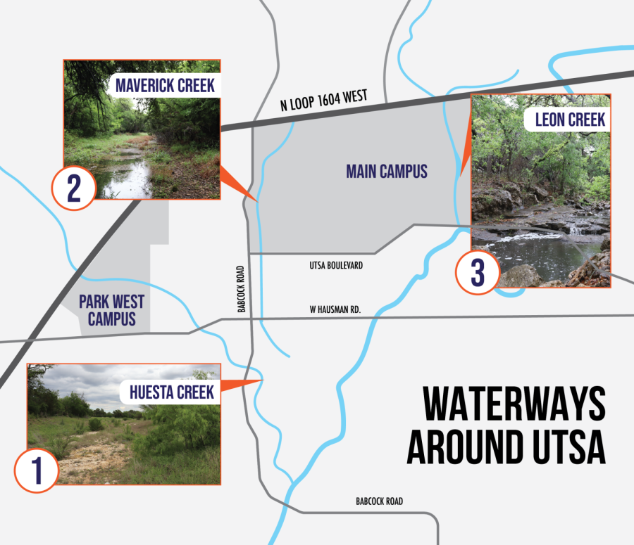
UTSA’s Main Campus sits between several nearby waterways that are displayed in the viewer.
A series of small reservoirs near East Campus Drive and Bauerle Road comprise the No Name Tributary of Leon Creek. This tributary is one of two waterways that flow near the Main Campus; the other is Maverick Creek on the West side of the campus. Huesta Creek flows just north of the Park West campus.
Mitigation procedures
Naturally, debris and obstructions will find their way in and along the waterways. The clearing of the creeks falls on the city.
“The City of San Antonio has jurisdiction over the flood plain, and they mitigate flood risks in our creeks through their flood plan mitigation program,” Jason Dempsey, UTSA’s executive director of safety and emergency management, said. “To ensure [an] open flow of water, the city contractually removes debris and obstructions from the creek channels every three years.”
Stormwater is often quickly channeled off campus and into the eastern reservoirs through storm drains, gullies and subterranean stormwater controls. Furthermore, the Main Campus sits on top of the Edwards Aquifer Recharge Zone.
UTSA utilizes a “Low-Impact Development” technique to capture stormwater and mitigate flooding.
“In 2017, the university implemented a policy of Low-impact Development to capture stormwater through our landscaping using bioswales, rooftop harvesting and bioretention facilities,” Dempsey said. “This policy minimizes flood risks downstream and decreases flash flooding. It also helps to recharge the aquifer and decreases the buildup of silt associated with stormwater runoff.”
UTSA’s plan of action
Dempsey assures a rapid, clear response is in place should flooding affect campus operation.
“In an emergency, the UTSA community will be well-informed through emergency alerts via text or email and information posted on university social media and UTSA Today,” Dempsey said. “Subscribing to receive emergency notifications via text message is another important way to ensure you receive emergency information and alert notifications as quickly as possible.”
Along with SARA’s floodplain viewer, UTSA utilizes several other tools to assess and analyze flood risks. They include FEMA’s Flood Maps database and the City of San Antonio’s Threat and Hazard Mitigation Plan.
Dempsey notes that flood risk mitigation can often be an evolving process.
“As with any emergency plan, flood risk mitigation is an evolving process,” Dempsey said. “We will continue to monitor and adapt our emergency management plan as needed as our campus grows, or as the San Antonio River Authority reports new or changing risk areas.”