Updated campus map provides functional search and modernized design
April 11, 2023
This past month a new interactive campus map was launched. The map was created to alleviate issues with old mapping resources.
The goal of creating the new map was to design a modern, user-friendly and accessible platform to serve as a resource for current and prospective students, faculty, families and anyone else interested in visiting UTSA.
Senior Communications & Content Specialist Drew Vincent explained the reasoning behind the update.
“We [had] a ton of maps that live[d] in different spaces,” Drew said. “There [were] a lot of challenges that were in place.”
Map production
While the need for the update was recognized before the pandemic, the project took flight a little over a year ago and required a large team working on it. Team members from Business Affairs, Enrollment, Campus Planning, Facilities, University Marketing and Information Technology helped make the map possible. Funding for the map came largely from the UTSA Office of the Vice President for University Relations.
The map was created with the third-party vendor, Concept3D — a company specializing in virtual tours and maps. Concept3D constructed the design and rendering based on information provided by the Campus Facilities and Planning team.
Program capabilities
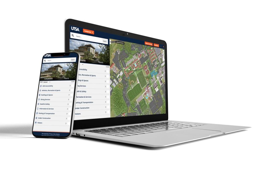
The program allows swapping between each of UTSA’s five campuses as well as virtual tours of campus hotspots. The new map allows users to filter and search by ADA Accessibility, Athletics, Recreation & Sports, Building & Spaces, Dining Services, Health & Safety, Information & Services, Parking & Transportation, Visitors and Building Labels. Responsive search includes the capability to search by building abbreviation or name. These capabilities provide straightforward navigation across campus and from class to class.
When exploring campus locations on the map, quick facts and descriptions are also available for reading below the name and location. Vincent demonstrates the thought behind this feature as delivering “the chance to not only just say, ‘Here’s how you get to different areas on campus,’ but [also] here’s some of the history and some things that make our university unique — the things that stand out.”
Another new feature of the map is the option for Wayfinding. Wayfinding provides directions from anywhere off-campus to an on-campus location. It operates similarly to Apple or Google Maps but provides users with more specific directions for navigating to buildings and locations on campus.
The map proves essential for those new to or visiting campus.
“We’ve done a lot of work with the parking overlay so that when you’re bringing people, you can look and search for specifically like, ‘Where can I pay to park?’,” Vincent explains. “We’re also using this as an opportunity to bring in new Roadrunners. We have built-in tours [that tie] into virtual tours. They come to our housing options, and they can tour our campus virtually. There’s a lot of really cool stuff that’s all just kind of packaged together.”
Going forward
With the map being less than a month old, Vincent explains “[that it] is still very much a work in progress.”
The map team encourages users to fill out the feedback form if they experience any difficulties or detect other points, such as the map not accurately reflecting how people walk around campus. The feedback form is located in the top right corner when viewing the map.
In the coming weeks, the permanent team in charge of the map will meet, view feedback, make changes and analyze the map data.
The map is available for use at map.utsa.edu on both mobile devices and computers.